It takes two (for a disaster) to tango
Guest author Antarin Chakrabarty explains how unravelling the complexities of urban systems can provide a route to simple solutions – but care is needed to avoid unintended consequences.


Fishing community slum of Sai Baba Sahi after updating with the help of a state government scheme (Photo: Antarin Chakrabarty)
In his book ‘Urban Dynamics’, systems scientist Jay W Forrester wrote that “most of our intuitive responses” with which we attempt to tackle the complexities of urban systems “have been developed in the context of what are technically called first-order, negative-feedback loops”.
In other words, we attempt to tackle complex systems based on intuitive responses that have developed from our experience of simple systems.
The bigger picture
Consider the following situation: I am sitting in my home in Delhi in June and naturally I feel very hot. There is only one variable that I consider with respect to my comfort and that is the temperature inside the room. I switch on the air conditioner which creates a negative feedback by reducing the temperature of the room and giving me comfort. In Forrester’s words, “the intuitive lesson is that cause and effect are closely related in time and space”.
However, the simple system of my room is embedded in the highly complex system of the city. When one person switches on the air conditioner, the temperature of the simple system (the room) goes down. When millions of people do the same thing, the temperature of the complex system (the city) goes up.
Complex systems are complex precisely because cause and effect are not related closely in time and space. The cause may be here and now, but the effect most likely would be at some other place, at some other time and create feedback for someone else.
Delicate balancing act
This holds true also for those regions that have done remarkably well in disaster adaptation, such as the cyclone-prone state of Odisha in eastern India. Odisha’s approach to tackling cyclones combines an early warning and cyclone-tracking system with a massive and brilliantly-coordinated relocation drive to move vulnerable families from the coastal villages to suitably equipped and located cyclone shelters.
Every year the state administration conducts one of the largest temporary relocation drives in the world by moving up to a million people out of harm’s way.
However, this effective adaptation system still causes substantial disruption in the lives and activities of people living in the coastal areas. While there is almost no loss of life, there are substantial losses to property, materials, agricultural produce and so on.
Interestingly, some researchers have pointed out that, contrary to popular assumption, the frequency and intensity of cyclones affecting the coast of Odisha are decreasing. But even if this observation is correct, the net exposure, and consequently damages due to disasters, will still keep increasing.
This is due to the fact that disaster intensity and frequency are only one part of the equation. If the rate of decrease in the frequency and intensity of disasters is surpassed by the rate of population growth and urbanisation in the cyclone-affected districts of the state, then the impact of cyclones is likely to increase rather than decrease.
Over time the positive feedback (increasing the impact of the disaster) effect of these second order rates might overwhelm and negate the negative feedback (decreasing the impact of the disaster) effect of the first order rate. The government may keep on constructing cyclone shelters and yet find the effectiveness of their cherished strategy declines over time.
In the eye of the storm
In fact, there are signs that is already happening. In certain villages of Odisha, people refused to be relocated to shelters as cyclone Dana approached earlier this year. They did this to protest against the government’s failure to grant them pattas (land titles), which had an effect on their not being able to invest in the construction of pucca (solid, resilient) houses.
A fact often overlooked is that it is primarily the families living in kutcha houses (made of temporary materials like mud, bamboo and thatch) that need to be relocated to the cyclone shelters.
While listing the standard cyclone preparation measures undertaken by the state administration, the ‘Memorandum of Cyclones’ published after each cyclone by the office of the special relief commissioner clearly states that the concerned district administrators are advised to "identify all vulnerable people living in kutcha houses or living near the coast or in low lying areas and shift them to multipurpose cyclone/flood shelters and other safe shelters".
I was in Bhubaneswar, the capital of Odisha, when the eye of the devastating cyclone Fani passed right over my apartment on 3 May 2019. While I almost got PTSD [post-traumatic stress disorder] from witnessing the wrath of the cyclone, which broke the backs of almost every tree in the city with its speed of 250 kilometres per hour, it was no match for the power of good old reinforced concrete and burnt bricks, held together by cement mortar.
In fact, that’s what a cyclone shelter essentially is – a pucca building.
Advanced adaptation strategy to create negative feedback
However, this also suggests that the cyclone adaptation strategy of Odisha is a function of the total number of kutcha houses in the cyclone-affected districts of the state and that, in turn, is a function of, among other things, the rates of growth of population, economic development and inequality in the same region.
An advanced adaptation strategy could, therefore, combine the present strategy of cyclone monitoring and relocation, with other ongoing schemes of settlement upgrading and transformation.
The following map shows the location of cities containing major fishing community slums of Odisha:

Map showing the high cyclone risk zone of Odisha state. This was prepared by the author using GIS software and combining data from mentioned sources.
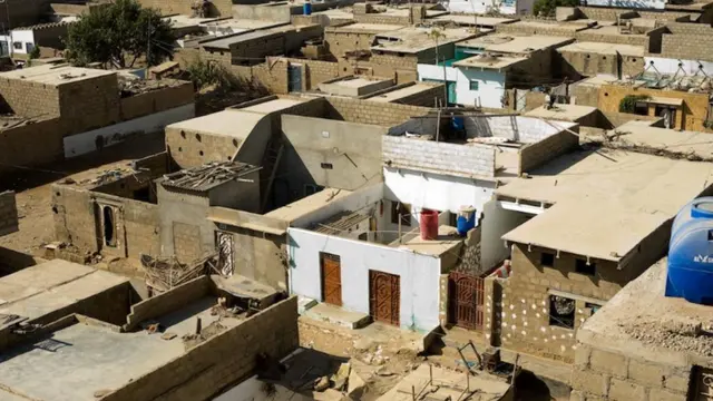
The following photos show the transformation of the fishing community slum of Sai Baba Sahi in Gopalpur as a result of Jaga Mission, a state government scheme aimed at granting land rights to slum dwellers and undertaking comprehensive upgrading of their settlements.


Transformation of community slum in Sai Baba Sahi, showing the village pre-construction, during and after. Click on the images to enlarge them and scroll through (All photos: Antarin Chakrabarty)
As part of the housing component of the mission, the possession of land rights allowed the slum dwellers to also avail themselves of the support provided under the central government’s affordable housing scheme – and construct pucca houses.
While Jaga Mission is seen as a slum empowerment scheme, and not directly linked to Odisha’s cyclone adaptation strategy, it is clear that as part of a higher order system, it helps create a negative feedback by reducing the impact of cyclones on some of the most vulnerable people living and working along the coast.
Nature would still want to dance a stormy tango. But by incorporating the art of managing complex systems into our climate adaptation strategies, we may just be able to calm it down to a slow waltz.
More on data tales
We invited Antarin Chakrabarty to contribute to this blog series and reflect on his experience working in Jaga Mission, the state of Odisha’s ambitious slum upgrading programme. His particular interest is how well this was served – or not served – by GIS.
- Data tales part one looked at the generation, ownership and use of geographic information system (GIS) data to underpin the slum upgrading programme – or often the non-use.
- Data tales part two reported on what the author found when he went looking for relevant data. Despite being told by government officials that no such data existed, he discovered vast resources that were not being used.
- Data tales part three revealed the (unexpected) technological prowess of the urban poor.
- Data tales part four showed how the lack of relevant or accurate data on climate risk and resilience in slums could be resolved by making community-based data collection the norm.
- Data tales part five questioned whether the computing power at our fingertips is being used to best effect, and frustrations that ensued during the project.
- Data tales part six looked at successful slum upgrading scheme in Odisha, India, analysing the diverse range of institutions that own land and the complexity in getting tenure for their residents.