How rural communities are rewriting the story of AI
Advancing nature-based solutions for climate resilience

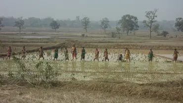
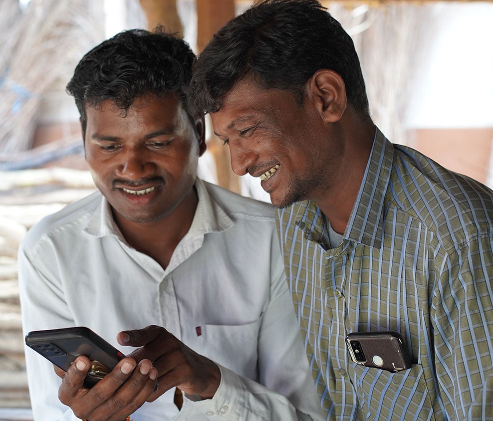
Farmer Rukmani Bai introduces her community to the CRISP-M tool, which uses AI as a partner to increase climate resilience (Photo: H&K Communications/IIED)
When most people think of artificial intelligence (AI), they think of tools like ChatGPT: programmes that can generate text, create images or summarise information by analysing vast amounts of online content. But for a farmer exposed to the climate crisis trying to decide what to plant, or a family deciding whether to take a loan, this kind of AI can feel a world away.
CRISP-M is a different kind of AI. It is a decision support tool that turns complex climate and landscape data into clear, map-based information that communities use to plan water harvesting, conserve soil and protect their livelihoods.
My father used to tell me stories of farmers committing suicide, unable to bear the brunt of extreme weather conditions. The information available on CRISP-M has not only helped me take better care of my crops but has also given me hope that things can change for the better if we work together
– Brajlal Baribal, 27, soya bean, pigeon pea and maize farmer
Unlike generative AI, which relies on heavy computing and consumes vast amounts of energy, CRISP-M functions offline on ordinary smartphones, keeping its carbon footprint modest while delivering high-impact results.
What this looks like in practice is best understood through the experiences of people who use CRISP-M in their daily lives.
Rukmani’s story: from being unheard to being part of the plan
“Rainfall pattern has changed in the past few years. It does not occur at the time as it used to previously occur. This leads to loss of standing crops ready to be harvested.”
Rukmani Bai, 55, lives in the remote village of Barela in Madhya Pradesh state, India. She said this quietly, sitting under the shade of a tree where the women of her village often gather. The other women nodded. The monsoon no longer follows the patterns they grew up relying on. And when rain becomes unpredictable, families cannot plan the way they used to.
For Rukmani, this uncertainty impacts her ability to feed her family. Since her husband fell ill, she has carried the responsibility of feeding and sustaining their large family. She now farms the family land, growing wheat, maize and gram (chickpeas). But because the land is not in her name, she has often been unable to claim government support meant for marginal farmers. And in village meetings, she has faced discrimination and dismissal, without her husband’s presence and support.
The year her crop failed, the food in her house ran out early. “Under such circumstances,” she said, “my family will go hungry unless I took a loan. I did not know what to do.” The loan pushed her into debt that she knew she might not be able to repay.

Climate change can add stress and hardship to already under-pressure farmers (Photo: Hindustan Times)
Across Barwani, Raisen and Sehore districts in Madhya Pradesh, others told similar stories: a sudden downpour washing away prepared topsoil; fields drying too soon; wells running dry by August. For these farmers and for millions like them, the climate is changing fast, and old ways of reading the seasons are no longer enough.
India’s Mahatma Gandhi National Rural Employment Guarantee Scheme (MGNREGS) is designed to act as a safety net in these situations. It provides up to 100 days of paid work per year (150 during severe drought) while creating village assets such as water-harvesting structures, soil conservation works and plantations.
In practice, however, the groups most exposed to climate variability, such as women, Indigenous communities and landless workers, are often excluded from decisions about where these assets are built and who gets work. Village meetings are frequently dominated by a few powerful voices, while those bearing the gravest risks remain unheard.
People like us don’t get to decide things. We only follow what we’re told
– Rukmani Bai
That began to change when a climate saathi (Hindi for ‘friend’), a local volunteer trained to use the CRISP-M tool, arrived with a smartphone. He showed the villagers a detailed map of Barela and the surrounding fields, with information layers that could be switched on and off, showing slope, drainage, soil moisture and rainfall patterns.
When he tapped on a field on the map, the app suggested a structure that could help conserve soil moisture, based on GIS analysis and future climate projections. Most importantly, the information was not an instruction. Rukmani could accept the suggestion, modify it, or, if she felt the options were not suitable for her land, she could reject it.

A climate saathi supports the geo-tagging of a local check dam using CRISP-M. With an accurate picture of existing infrastructure – and any repairs needed – communities can plan effective preemptive action (Photo: H&K Communications/IIED)
“Earlier, I only used the phone to make calls,” she said. “Now I can open it and navigate through the app. Climate didi (saathi/friend) also explained how to talk to the phone and get information. I am now teaching other women to use it.”
Why we built CRISP-M
Climate impacts can devastate livelihoods in poor rural communities. Yet the information that could help people anticipate drought, manage water or plan land-based works often does not reach villages in a usable form. Data may exist at the national or state level, but it rarely arrives in a form that communities – or even local officials – can easily understand, interpret and act on.
We developed CRISP-M to address this gap. Its purpose is not to generate new climate data, but to translate existing climate and geospatial information into choices that can be discussed, questioned and acted upon within village planning processes, particularly under MGNREGS, where decisions about the construction of land and water assets can directly shape climate resilience.
How CRISP-M uses AI to build climate resilience
Unlike the widely-publicised large language models that can be trained to generate text or run chatbots, CRISP-M uses AI to support communities to prepare for drought, manage water scarcity and protect their livelihoods during climate stress.
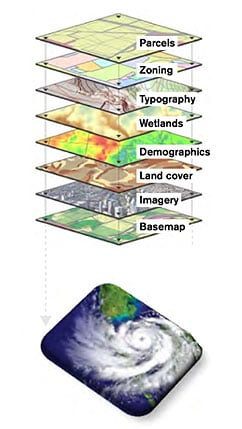
It integrates numerous datasets, including rainfall, soil moisture and vegetation indices and 10 layers of geographic information system (GIS) data.
The GIS layers show the latest satellite data for administrative boundaries, watershed boundaries, land use, geomorphology, geology, groundwater prospects, lineament (natural fractures in underlying rock that influence how groundwater moves), drainage polygons and contours.
Each of these layers is digitised separately and can be viewed at a resolution of 2.5 metres, providing accurate, detailed estimates of ground conditions, alongside future climate projections.
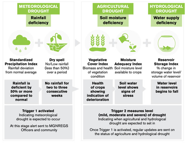
How CRISP-M uses AI to assess conditions and provide drought warnings (Source: iied.org/20531iied)
For resilience planning, the application provides information about local geo- and bio-physical characteristics and potential climate risks and resilience measures on users’ mobile phones.
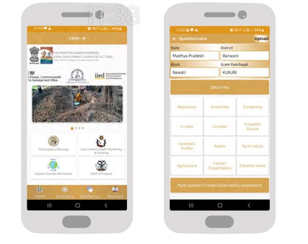
The CRISP-M dashboard on a mobile phone (Images: IIED)
From this, the app delivers three functions for communities:
- Early drought warnings, not only meteorological, but also agricultural and hydrological, using transparent thresholds aligned with India’s drought management guidance, so local actors know when to act
- Ridge-to-valley watershed planning that translates GIS information into site-specific, nature-based structures (ponds, check dams, trenches, pasture/afforestation plots, field bunds) that are future-fit, and
- Community monitoring via geo-tagged photos so people can verify assets that have been built, highlight where repairs are needed and see progress as it happens.
Why this approach works
Long-term drought-proofing is not about building a single large structure. It depends on managing how rainwater moves across the entire village landscape, from ridge to valley. Slowing water runoff, increasing groundwater recharge, harvesting surface water and conserving soil moisture mean that even a short monsoon can deliver the water needed for agriculture, livestock and drinking throughout the year.
CRISP-M enables this by allowing villagers to visualise how water flows across slopes, fields and drainage lines. Standing on a slope, a user can drop a pin on the map, review the likely water yield and explore site-appropriate structure options. Over time, this builds a comprehensive village-wide plan to conserve and store water across the entire landscape, strengthening long-term drought resilience.
Working with communities to make AI accessible
We developed CRISP-M using a design process that spanned 18 Gram Panchayats (village councils) in Barwani district. We aimed to build a learning process to answer one practical question: how can climate-informed GIS planning strengthen village decision making so that MGNREGS works are more effective, inclusive and accountable?
To do that, we worked through the spaces where village decisions are meant to happen, especially Gram Sabhas (village assemblies). We demonstrated early design versions of CRISP-M during planning discussions, using the maps to propose asset locations, review watershed treatments and talk through drought preparedness.
In each round villagers gave us practical user feedback: which maps were confusing, which indicators helped people make decisions, what information felt overwhelming, and how the tool needed to work in low connectivity settings.
Scientific and institutional partners backed this design approach. The Madhya Pradesh Council for Science and Technology, the Indian Meteorological Department, the National Remote Sensing Centre and the Indian Institute of Tropical Meteorology helped ensure data access, quality and technical robustness. The Ministry of Rural Development and MGNREGS functionaries worked with us throughout to ensure that the tool worked for the actual planning and approval process set out under the programme.

The community gathers at a village meeting to learn about the CRISP-M tool (Photo: H&K Communications/IIED)
At the same time, village communities, frontline staff and local elected representatives shaped the tool in practical ways, such as commenting on icon choices, language, workflows, offline functionality and photo-based verification.
Over nine months of iterative testing, CRISP-M evolved from a technical prototype into something people felt confident using and that government teams could apply within routine MGNREGS planning.
From pilot to scale up
After Barwani, CRISP-M was tested as part of a wider operating model in Raisen and Sehore districts in Madhya Pradesh. A cadre of climate saathis or local village volunteers were trained to support others to use the tool. They helped embed CRISP-M into Gram Sabha planning, asset verification and follow-up.
As confidence grew, the Ministry of Rural Development integrated CRISP-M into MGNREGS planning processes across multiple states, so the tool’s outputs could directly inform decisions on what works were selected, where they were located, and how they were sequenced.
At the national launch, the Indian Rural Development Minister said embedding climate information into GIS-based planning would “open up new possibilities for our rural communities to deal with climate change.”
People plus AI: the climate saathi model
At the centre of our approach are climate saathis. They become part of everyday planning, implementation and monitoring under MGNREGS, including supporting the decision making about land and water works (including ponds, bunds and trenches), verification of what has been built and follow-up on issues such as delays, repairs and inclusion.
Take the story of Dinesh Kumar Purvi, 32. A subsistence farmer who once had to migrate to the city for labour to pay off debts due to crop loss, Dinesh volunteered to become a saathi. As part of his role as climate saathi, Dinesh was given training and mentorship in how to use the tool. Recognising the kind of change the scheme was capable of making in the lives of others like him, he started helping villagers to fill out job applications, and apply for the unemployment benefits they’re entitled to.
Previously, Dinesh was unable to access any information about MGNREGS. Now he and other households can verify the claims on the progress of work, report the actual status of the works undertaken and highlight any structure needing repair or maintenance.
The climate saathis don’t replace government officials. Their role is to ensure information is understandable, accessible and usable by everyone. Saathis also create a learning loop, feeding local insights and usability information back to technical teams, so the tool improves based on real use.


Putting the CRISP-M tool into practice: from design and consultation to education and implementation. Click on each image to enlarge it and then scroll through (Photo: H&K Communications/IIED)
How CRISP-M is supporting climate resilience at the grassroots
The most visible changes triggered by CRISP-M have been social and institutional. It changed who has access to information, how decisions were made and whose priorities shape village plans. Across Barwani, Raisen and Sehore, impacts emerged along six interconnected dimensions:
1 Gender: information shifts power
Women are central to farming, livestock care and water collection in rural India. But they are often left out when decisions are made about land, water and public works. CRISP-M changes this dynamic by putting the same planning information that engineers and officials use into women’s hands.
Women like Rukmani began using the app to track rainfall trends, assess water stress and review structure options for their land. Supported by Climate saathis, they learned to read maps, compare alternative options and ask why a structure was proposed in one location rather than another.
Rukmani’s confidence grew not because the technology was simple, but because she had evidence she could point to. As she put it, people in village meetings began looking at her with “respect and awe” when she shared information from the tool.
Women like Saraswati Uikkey, who is from an Indigenous Scheduled Tribe community, faced what many women in her position face: double discrimination – for being tribal and for being a woman. Deserted by her husband, with no land to farm and children to support, she relied on casual labour and MGNREGS work. CRISP-M helped her move from quietly coping to pushing back, using outputs from the tool to question delayed wage payments and argue for works that mattered for her hamlet.
Saraswati described how she persuaded other women to use CRISP-M: “Initially, when I went to the village, women would say that these things are not for us. I started showing to them how the information in the tool can help them get both wage employment and water-related structures near their field. They started understanding the value of it.”
Women’s self-help group members also began using CRISP-M collectively to advocate for water-saving structures near plots they cultivate, common lands they manage and places where they collect water or fodder. Over time, issues that rarely featured in MGNREGS planning, like walking distance to water bodies, fodder access and soil moisture on marginal plots, started coming up more consistently.
2 Marginalised and Indigenous groups: making voices heard
For many Scheduled Tribe and Scheduled Caste households, exclusion is both social and spatial. Families living on hill slopes, forest edges or marginal land are often left out of discussions when structures are planned based on convenience rather than need.
CRISP-M, combined with participatory vulnerability assessments, gives these households a way to demonstrate risk rather than merely describe it. Farmers like Suresh used maps to show how rainfall runoff moved across their fields, where erosion began and why upstream structures matter more than building another pond near better-connected landholders.”
Earlier, I did not understand one thing in these maps, but now I know how to see things closely and understand it. People in the village now come to me to help them get the information they want from the tool
– Suresh
 meeting")
Suresh voices his opinion at a Gram Sabha (village assembly) meeting (Photo: H&K Communications/IIED)
And it changed how Suresh felt about village meetings, too: “Earlier I did not join these meetings because it would be a waste of time… Now we have the information, and we know we have the right to demand water conservation work on my field… Now I have a field bund sanctioned on my farmland.”
For the first time, GIS-supported planning was happening in the village, not in distant offices. People who had previously been ignored in planning meetings could point to their hamlet on the map, interpret indicators and argue for priorities with evidence. Being heard in this way restored their confidence and led to tangible changes in asset placement.
3 Early warning and early action: reducing distress and supporting choices
One of the most valued features of CRISP-M is its drought early warning system. Unlike traditional alerts based solely on changes in rainfall patterns, CRISP-M integrates meteorological, agricultural and hydrological indicators. In practical terms, this means the warning reflects not only whether rainfall is low, but whether crops are under stress and whether water availability is reducing.
For a small farmer like Gulab Singh, 40, this changes the kind of decisions he can make and when. Instead of waiting until losses pile up, he can adjust sowing dates, crop choices or irrigation plans earlier. He described that shift as a real ‘before and after’: “I was amazed that I could get such information in advance and make decisions about crop selection and harvesting accordingly.”
Early warning mattered for landless workers, too. It helped people decide whether to stay and rely on MGNREGS work or migrate temporarily. And for village institutions, it enabled earlier planning for the additional 50 days of employment triggered during drought periods.
This anticipatory use of information reduced emergency borrowing, helped households plan fodder and livestock care, and avoided distress migration. Instead of reacting after losses have occurred, families could act earlier, when they still had options.
4 Landscape-based planning: from scattered works to long-term drought proofing
Historically, assets created as part of the MGNREGS scheme were often implemented in isolation, such as a pond here, a check dam there, without considering how water moves across the landscape.
CRISP-M helps communities to visualise ridge-to-valley connections, identify erosion hotspots and plan sequences of structures that make ecological sense . Small and marginal farmers began arguing for upstream treatments rather than works located near larger farms.
Some villagers described this as a change in who holds the expertise.
Engineers had come to our village to plan out everything… With CRISP-M tool, we are all technical experts now. We choose the land, and where and what type of structure to build
– farmer
Villages reported a stronger emphasis on works that supported soil moisture retention, groundwater recharge and improved fodder availability, thereby strengthening both drought and flood resilience.
5 Transparency and accountability: community-based monitoring in practice
CRISP-M allows community members to take photos and add information about existing structures with geo location codes and time/date stamps to show the status of assets created. This reduces ambiguity around whether works have been completed, repaired or maintained.
Farmers like Dinesh Kumar used the app to document damaged structures that had gone unattended for years. Women’s groups collectively verified assets and were able to raise issues using detailed evidence – rather than just making accusations. For them, this was the first time official progress data was visible on their own phones.

Climate saathis take a look at Dinesh’s farm pond, which broke after heavy rainfall. Subsistence farmer Dinesh, 32, had to borrow money to get food for his family and was forced migrate to the city to earn money to repay the loans. Today he volunteers as a climate saathi (Photo: H&K Communications/IIED)
“Earlier, the individual and community work were finalised at the Panchayat level without ascertaining the needs of [the] community,” said Dinesh, describing the shift. “We now challenge the Panchayat’s decision.”
This community-based monitoring strengthens accountability between workers, frontline staff and Panchayat institutions and builds trust that the system can be responsive.
6 Integrated planning across sectors: connecting land, water and livelihoods
By displaying land use, slopes, forest boundaries and drainage on a single map, CRISP-M makes it easier for communities to see the connections between land, water and livelihoods and to plan beyond a list of separate works.
Villagers began aligning water-harvesting structures with agricultural inputs, fodder development from other programmes of agriculture department, ridge-level afforestation with forest budgets, and youth skills training with local resource needs. In many cases, the community initiated this alignment rather than officials, because villagers could see and share the relationships between land, water and livelihoods.
Over time, village development plans gradually shifted from lists of disconnected works to more coherent, ecosystem-based strategies, rooted in a common understanding of the landscape.

Continuous contour trenches collect water flowing downhill to be used in irrigation (Photo: H&K Communications/IIED)

The site of a proposed new trench that would protect villagers in Bisanjpur Tandi from erratic rainfall and prolonged dry spells (Photo: H&K Communications/IIED)
A new way of thinking about AI for climate resilience
The experience of Barwani, Raisen and Sehore highlights a broader lesson: CRISP-M worked not simply as a digital tool, but as an operating model that reshaped the relationship between data, public programmes and community decision making.
Co-development is essential. CRISP-M gained traction because communities, social protection officials and local governments shaped it from the outset. Our technical partners ensured data quality and availability, while the Ministry of Rural Development ensured policy and programme alignment.
This joint involvement meant the tool was not imposed as an external solution, but evolved into something that local stakeholders can use to improve the delivery of ongoing programmes.
Information must be usable, not just open. India does not lack climate or geospatial data. What it lacked was the translation of that data into decisions people could act on.
When CRISP-M converts the 10 complex GIS layers and drought indicators into simple, place-based choices (what to build, where, and in what order), the previously inaccessible datasets become meaningful tools for building climate resilience.
Early warning only matters if it triggers early action. CRISP-M provides early warnings that align with how farmers and workers actually make decisions. Communities used this information to adjust sowing dates, plan wage demand under MGNREGS, prepare fodder or avoid high-interest loans. The result was not just better preparedness, but better ability to cope with drought and water scarcity before they spiral into deeper losses.

Loss and damage is avoidable if responses are timely. For households already close to the edge, a failed crop, lost wages, distressed migration or the drying of a village well is an immediate economic loss – and often a non-economic loss too, causing anxiety, insecurity, disrupted schooling, loss of dignity and even suicide. CRISP-M does not ‘solve’ loss and damage, but it does help reduce avoidable losses by making risks visible earlier and by connecting information to practical, funded actions within a public works programme.
Transparency builds trust and keeps systems working. Geo-tagged, community-verified monitoring reduced ambiguity around asset creation and maintenance. This strengthened accountability between workers, frontline staff and Panchayats, and helped shift monitoring from a compliance exercise to a shared responsibility.
Scale depends on institutions, not apps. We developed CRISP-M to strengthen the implementation of an existing national programme with earmarked budgets and delivery systems, not as a standalone digital product. From the start, we secured buy-in from the government and worked with MGNREGS functionaries to shape the design, test what would work in practice, and integrate it into existing planning cycles. As a result, local officials feel a sense of ownership of CRISP-M and have actively supported getting it adopted and scaled to more communities.
Scaling: from CRISP M to U CRISP
The world has more climate data than ever before. Yet in thousands of villages, farmers and workers face an increasingly erratic climate and are forced to make high-stakes decisions about crops, water and work using guesswork because the information they need is not available to them in a usable form.
That gap is not only technical. Planning systems are often reactive, and public programmes with significant budgets for land, water and livelihoods don’t always have a simple, climate-informed process that communities can use and trust. When systems respond late, the result is predictable: avoidable losses accumulate. Crops fail, livestock productivity drops, water sources dry earlier, wages disappear and families take on debt or migrate. Delayed action turns climate risk into loss and damage.
We developed Universal-CRISP (U-CRISP) to bridge this gap.
U-CRISP retains the core features that made CRISP-M effective, such as explainable analytics, early warnings linked to action, ridge-to-valley planning and community-based monitoring, but is designed to be adapted across different geographies, ecosystems and government programmes.

Rukmani Bai shows off the CRISP-M tool, which is now being scaled up and aligned with national planning cycles and programmes (Photo: H&K Communications/IIED)
These may include social protection systems, watershed and land management programmes, disaster risk management frameworks, forestry initiatives or local development plans. The central focus remains the same: co-development with communities, alignment with government systems and an intermediary layer that bridges people and data.
Scaling, however, is a systems task rather than a matter of replicating a prototype. Experience from India suggests that U-CRISP adds the most value when three conditions are in place.
First, there must be a public mandate and a budget line that link climate-informed plans to funded works, so information leads to action rather than remaining advisory. Second, a trained intermediary cohort, equivalent to the climate saathis, is essential to make participation routine and to support communities in interpreting and using information. Third, open information flows across departments are needed to enable convergence between forestry, agriculture, livestock, skills and social protection programmes. When these conditions are absent, even well-designed tools struggle to move beyond pilots.
Partnering to implement U-CRISP
U-CRISP is now ready to be adapted with partners who want to adopt a people plus AI approach to climate resilience, including:
- Governments seeking to make social protection or watershed programmes climate-smart and locally owned
- Philanthropies, funding agencies and climate funds looking for practical ways to deliver locally-led adaptation, anticipatory action and community-based loss and damage response that is transparent, auditable and grounded in community priorities, and
- Civil society and grassroots networks aiming to put climate information directly into people’s hands.
We aim to scale up U-CRISP with the same principles of co-development with communities, investment in local capacity building and meaningful partnership with government to align the tool with national planning cycles and programmes. This model shows how AI can support lasting and equitable climate resilience.
Rukmani’s first words were about worry and uncertainty. Today, she looks at the sky with more optimism because she has more agency and confidence in her future. The climate around her remains volatile, but she is no longer navigating it blindly.
As we move from CRISP-M to U-CRISP, the goal is not to export an AI tool. It is to carry forward a way of working in which the future of climate resilience is nature-based, people-led and AI-enabled, where communities like Rukmani’s are not just recipients of climate solutions, but are co-defining resilience-building.