Mapping for food safety
How and why communities in Nairobi’s informal settlements are creating and using maps to ensure their food and the people who sell it are safe

Children look upwards to a balloon that is part of a balloon mapping project
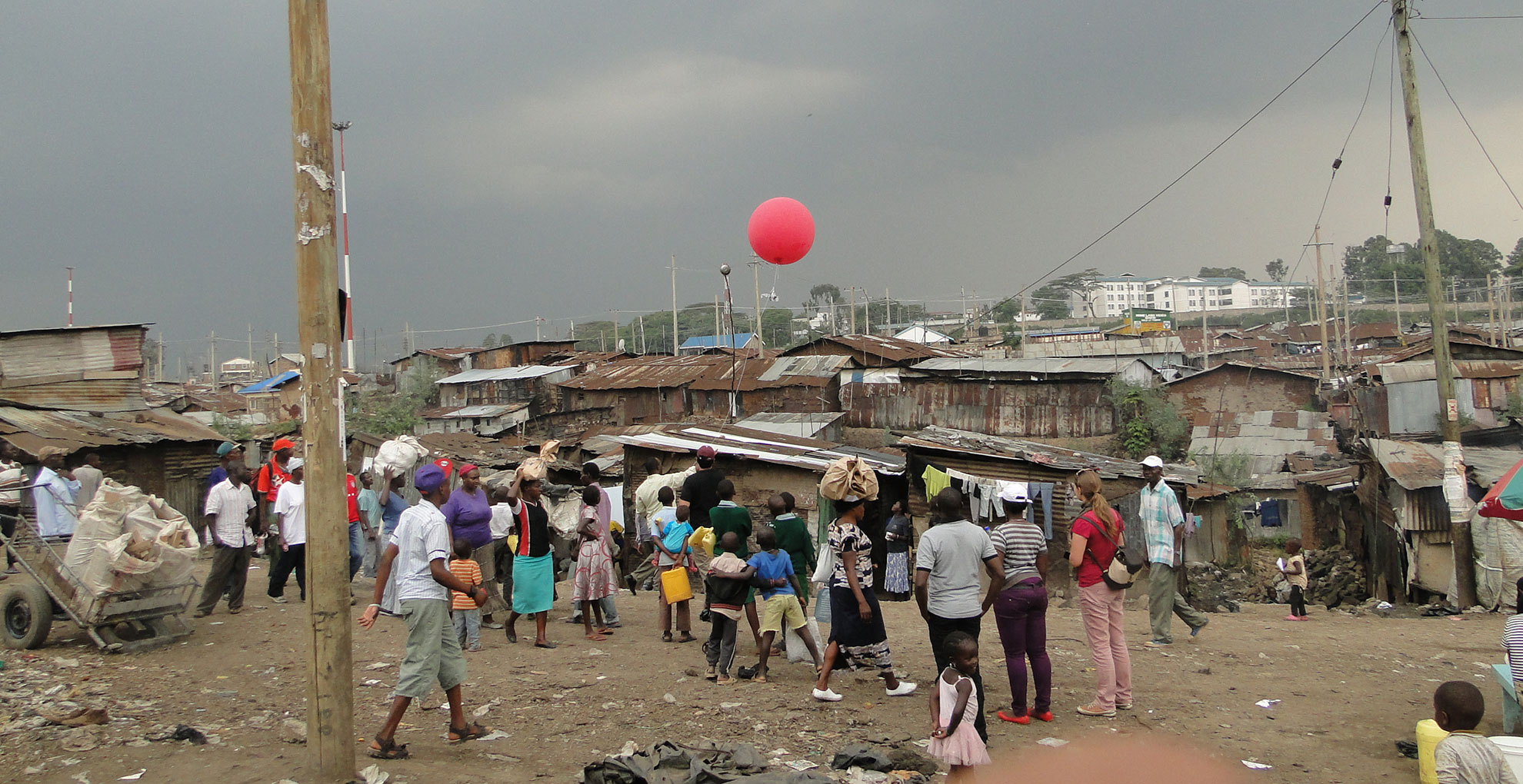
A red balloon more than a metre in diameter rises above tin roofs in Mathare, one of Nairobi’s biggest informal settlements. As the balloon’s handler walks through the narrow alleyways, a camera dangling from the balloon snaps a photo every second. This eye in the sky is helping the community identify and deal with threats to their daily food supplies.
The balloon is just one part of a mapping project led by community members and Muungano wa Wanavijiji, a federation of Kenyan slum-dwellers’ associations with support from partners in the Urban Zoo project. By creating the first maps to show food kiosks, mobile street vendors and hazards such as rubbish dumps and open sewers, the project is helping ensure that both food and the people who sell it are safe.

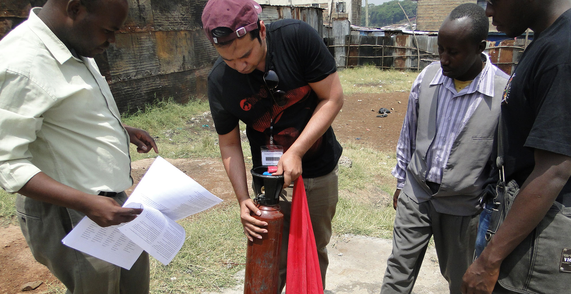
Mappers launch an air balloon in Mathare, Nairobi (Photo: Sohel Ahmed, DPU, UCL)
Here we describe how and why Muungano used this approach in Mathare and four more of Nairobi’s informal settlements.
Why maps matter
Informal settlements play key roles in city economies and are home to millions of people worldwide. In Nairobi, for instance, nearly two-thirds of the population lives one of 175 informal settlements. But governments and their official maps, surveys and censuses tend to ignore such places.
As a result, residents of informal settlements officially do not exist. Their lack of official documentation deprives them of basic services such as piped water, sewers, sanitation, health care, waste collection and schooling. It means they cannot open a bank account, register to vote and exercise all the rights of full-fledged citizens.
.")
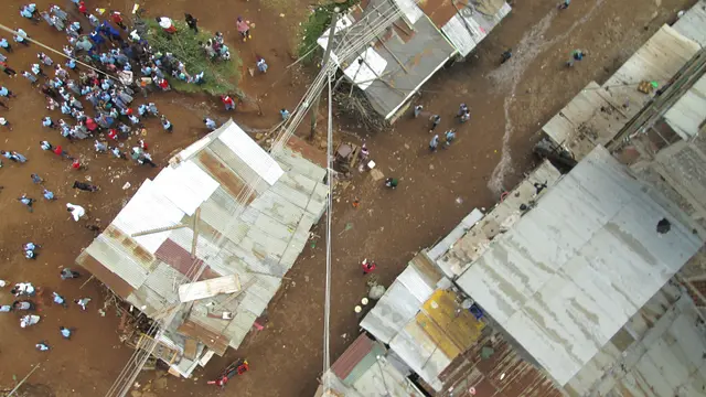
Surveying an aerial map of food safety threats in Mathare, an informal settlement in Nairobi Kenya (Photo: Sohel Ahmed, DPU, UCL)
Maps can shed light on the undocumented and the challenges they face. They can provide a platform for action and advocacy that addresses these challenges. But maps and mapping processes are political. They describe not only geographic boundaries but also what is within these boundaries. A map’s shape and content will therefore depend on who does the mapping.
Community cartography
Local communities rarely have opportunities to define their needs in processes that influence policy. As a result, development programmes are often ill–suited to local needs as they are based on top-down assumptions and misunderstandings rather than local realities. These issues can however be overcome with “methods of organization, mobilization, teaching and learning that build on what the poor themselves know and understand”.
Community-led mapping is something done by the people [rather than] something done to the people
– Dr. Muki Haklay, Co-Director of Extreme Citizen Science (ExCiteS), University College London
Shack/Slum Dwellers International (SDI), a network of organisations of the urban poor in 33 countries, has championed this approach through ‘enumeration’, a process by which organised “urban poor communities count themselves, document the lands they occupy and identify alternative lands for housing when needed”.
Through community-led mapping processes, local people can collaborate to define their geographical and social boundaries as well as their needs and challenges. By coming together and deciding how they want to describe their space and what story they want to tell, communities can develop a sense of self-empowerment—a feeling that something can be done to address the problems they face. As Muungano’s experience shows, the ways in which data are collected, analysed and reported are crucial to achieving sustainable results.
Focus on food
Like other SDI affiliates, Muungano has long used mapping and enumerations to gather knowledge local governments lack. It has used such knowledge to encourage local authorities to join forces with communities and develop solutions to problems the urban poor face. In 2012, Muungano members started thinking of ways to improve residents’ access to safe food and at the same time support food vendors, most of whom live in the settlements they serve.

Street vendor in Mathare (Photo: Paolo Cravero, IIED)
Food vendors are vital to Nairobi’s informal settlements, feeding thousands of people every day. Selling food is often the only way the vendors, who are mostly women, can make money. But they are often marginalised, stigmatised and even criminalised as a public health nuisance. To many policymakers they are simply invisible.
We saw where the vendors are, where the drainage and hazards are… through the balloon mapping we saw recent photos of the area, which are not up to date in Google maps
Julia Washera, a food vendor and Muungano member from Mathare
Muungano realised that data and mapping could challenge negative perceptions and highlight the crucial role food vending plays in generating income and providing the urban poor with affordable meals. Muungano worked with stakeholders from across the community, using a mix of mapping tools and deliberative meetings to explore problems and potential solutions. The project was community-led. Food vendors, livestock keepers, consumers of street food and others all took part and decided together how the project would unfold and how to use its findings.
It starts with dialogue
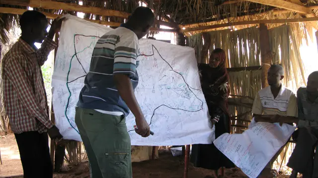
Before mapping could begin, conversations first flowed among community members about what to map, where and how. Muungano organised focus group discussions that enabled local stakeholders to answer these questions. To be effective, this phase of the process should be deliberative, open and unrushed. It takes time for stakeholders to reach a consensus about common challenges, priorities and how to proceed. In Muungano’s focus groups, participants identified and discussed what information was already available, what should be investigated and who should be included in future meetings.
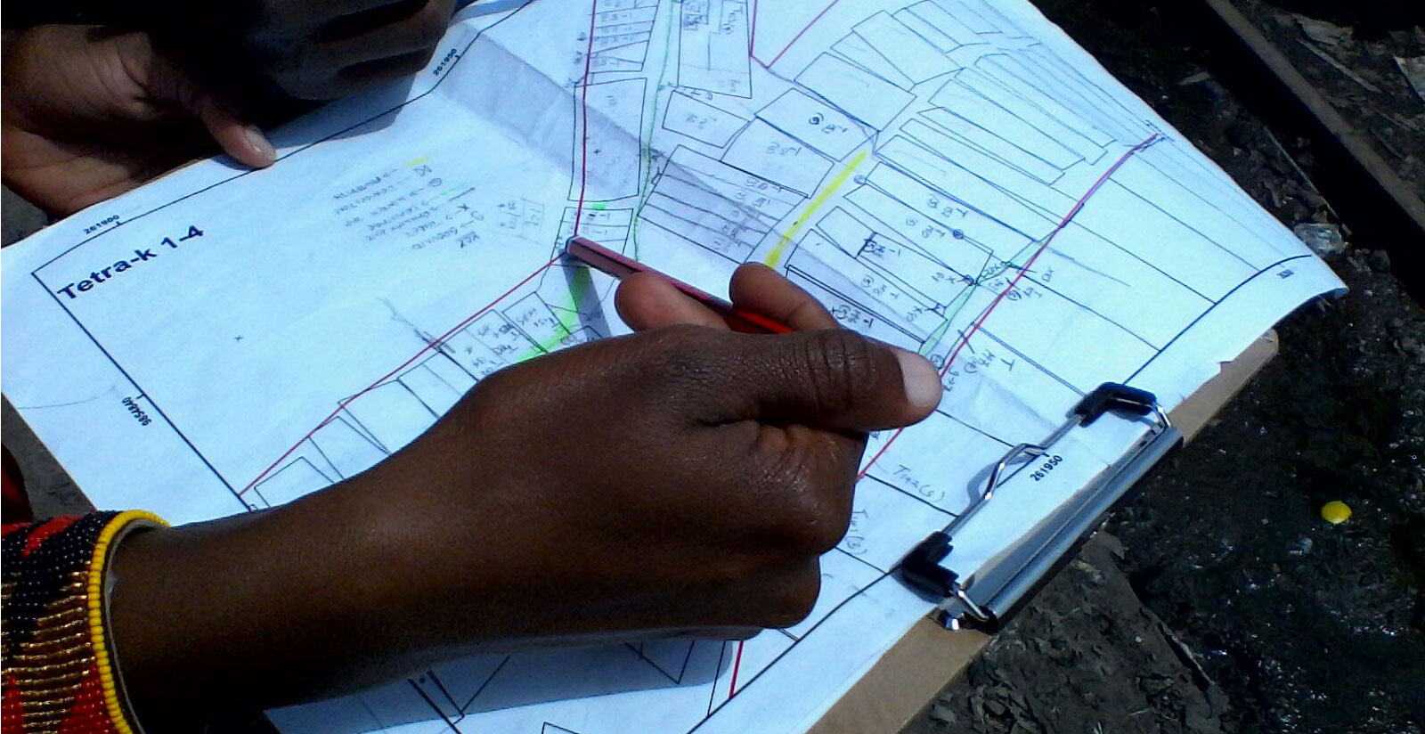
Subsequent meetings targeted specific interest groups in order to include and understand the various perspectives at play within the informal settlements. These ‘focus group discussions-plus’ used mental mapping exercises to capture local knowledge. Participants located themselves and their communities on paper and/or digital maps, and showed where services, environmental hazards, street vendors, schools, hospitals and other features are situated.
Some mapping processes go little further than this stage. They conclude by superimposing the different knowledge maps to create a composite and taking it back to the community for verification. Muungano pushed well past this stage to create hybrid maps by combining the indoor mental maps with data gathered on the ground and images captured in the sky.
Aerial mapping
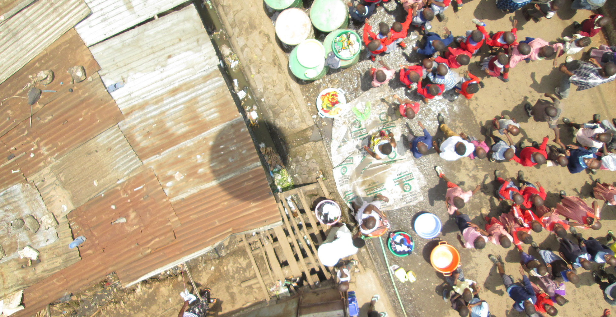
Aerial photographs integrated with on-the-ground mapping and data from qualitative research can illustrate the relation between residents, the space they inhabit and the activities occurring in it.
But communities cannot simply turn to free satellite images such as those on Google Maps, which are often obscured by cloud or are simply out of date. Companies producing such images have little interest in providing current images of informal settlements.

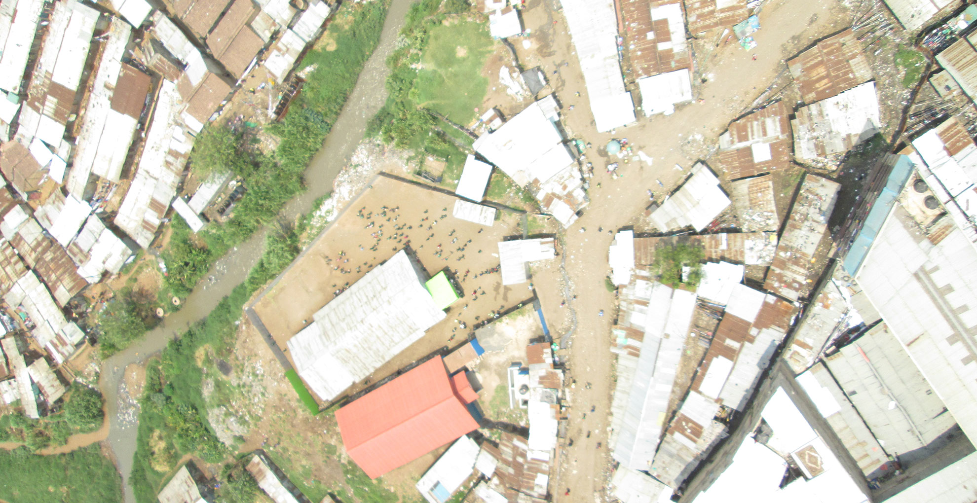
Georeferencing aerial images allows them to be combined with other maps. Here are aerial images from Mathare shown on a Google Map.
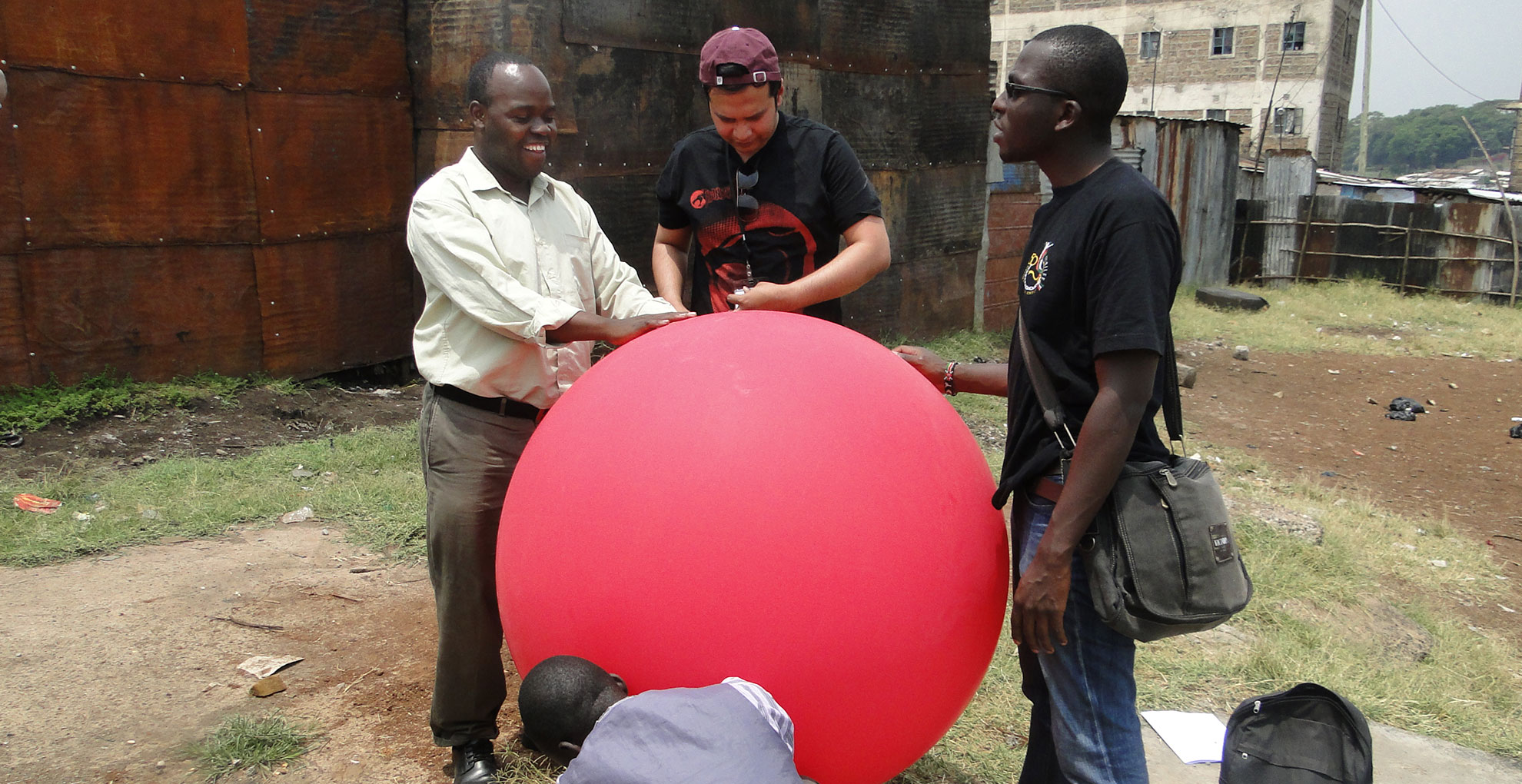
Low-cost tools such as balloons, kites and drones can, however, produce up-to-date aerial images of parts of the city official maps do not cover (see the guide to balloon mapping below). Through balloon mapping Muungano showed where food vendors operate, the environmental hazards they face in their daily work and the wider settlement’s layout including unoccupied areas.
Guide to balloon mapping
The Public Laboratory for Open Technology Science sells balloon-mapping kits for around US$100. Alternatively, you can build your own. This illustrated guide [PDF] explains how to construct and control a mapping balloon.
You will need:
 A weather balloon. These are available from specialist shops or online retailers. Prices vary from US$10-400, depending on the type of balloon needed. A UV-resistant balloon is less likely to deflate substantially during the flight.
 Helium gas to inflate the balloon. The place and legislation relative to purchasing helium vary from country to county. This table can help you work out how much gas you will need to lift your mapping kit.
 A basic digital camera. This would ideally be a cheap or second-hand camera as it will hang from the balloon during the flight. The camera must be able to take ‘continuous shots’ if the shutter release is held down, or have a time-lapse function to take shots at set intervals. You may need a rubber band to hold down the camera’s shutter release during the flight.
Memorycardcalculator.com lets you see how many pictures your SD memory card will hold.
 A 1–2 litre empty plastic bottle to mount the camera. Instructions are available on the Public Lab website.
 Some strong string or monofilament fishing line with a kite reel or similar device to secure and control the balloon. Make sure you also have a pair of gloves and some duct tape to hand.
Balloon mapping works best if there is little wind. In windy conditions, however, kite mapping may be a better approach.
At 20 meters, you get an image that gives a view of the street that helps you see the interactions happening in that street. This is not possible with satellite images. As the balloon goes a little higher… you start to see how the street interacts with the houses and other things that are happening in the settlement.
Jack Makau, administrator for Kenya at Slum Dwellers International
Making data count
Once the data collection and physical mapping are complete, the results and aerial photographs are shared and discussed with the community. During this process of analysis the primary concerns of residents emerge and are ranked by importance.
In the Mungaano project, this revealed links between food vending, urban health, food security and environmental hazards. The challenges that emerged include risks of contamination from pests, overflowing sewers, livestock and unsafe water, as well as poor hygiene and food handling practices. The analysis enabled community members to identify solutions to advocate for, such as:
- Training to improve food hygiene
- Clean-up exercises
- Designated waste disposal sites
- Improved water provision, sanitation and lighting
- Communal storage and refrigeration facilities


Gallery of 9 images: launching a balloon and resulting dialogue.
This [process] has helped the community understand the issues of health, safety, and wellbeing. The collection of data, the trainings, the awareness, the mobilization, have helped the community […] to understand their issues so that they can push the bigger agenda of the Federation and of the community
Rashid Mutua, National Chairperson Muungano wa Wanavijiji
I’m struck by how successfully a balloon can take an aerial map of my settlement. I am aware there is a hidden camera in the balloon, this is a noble innovation
– Community observer of the aerial mapping process in Mathare
This final phase of community-led mapping is fundamental as it is also the start of a new process of engagement and negotiation with local government. In this context, organized urban poor communities can support their claims with verifiable data gathered through an inclusive mapping process.
By putting themselves on the map, the food vendors of Nairobi’s informal settlements have shown how they much they matter to local food security and what local government and residents can do to recognise and support them. They have become visible.
Contact us
Dr Cecilia Tacoli, principal researcher, IIED Human Settlements Group: [email protected]
Jack Makau, administrator for Kenya, Shack/Slum Dwellers International: [email protected]
Partners
Muungano wa Wanavijiji spearheaded this process with support from the Muungano Support Trust, the International Institute for Environment and Development (IIED) and the Development Planning Unit (DPU) at University College of London (UCL). This process led to further research providing gender-sensitive analysis of food vendors’ contributions and challenges in two other Nairobi settlements (Korogocho and Viwandani) in collaboration with the Africa Population and Health Research Center and the International Livestock Research Institute. Muungano is an affiliate of Shack/Slum Dwellers International.

This research was funded by UK aid from the UK Government, however the views expressed do not necessarily reflect the views of the UK Government. We also acknowledge the Medical Research Council, Natural Environment Research Council, Economic and Social Research Council, and Biotechnology and Biosciences Research Council for the funding received for the Epidemiology, Ecology and Socio-Economics of Disease Emergence in Nairobi project through the Environmental and Social Ecology of Human Infectious Diseases Initiative (ESEI), Grant Reference: G1100783/1.