
Primary

  • About
  • News and insight
  • Our approach
  • Publications
  • About
  • News and insight
  • Our approach
  • Publications
Sign up for our newsletters
  • Biodiversity
  • Climate change
  • Communication
  • Drylands and pastoralism
  • Economics
  • Energy
  • Fisheries
  • Food and agriculture
  • Forests
  • Gender
  • Governance
  • Land acquisitions and rights
  • Law
  • Monitoring, evaluation and learning
  • Natural resource management
  • Policy and planning
  • Poverty
  • Sustainable markets
  • Urban
  • Water

Secondary

  • Urban
  • Climate change
  • Biodiversity
  • Natural resource management
  • Food and agriculture
  • Sustainable markets
  • Policy and planning
  • Forests
  • Governance
  • Communication
  • Economics
  • Poverty
  • Monitoring, evaluation and learning
  • Land acquisitions and rights
  • Energy
  • Law
  • Gender
  • Drylands and pastoralism
  • Fisheries
  • Water

Search IIED

  • About
  • News and insight
  • Our approach
  • Publications
Sign up for our newsletters
  • Biodiversity
  • Climate change
  • Communication
  • Drylands and pastoralism
  • Economics
  • Energy
  • Fisheries
  • Food and agriculture
  • Forests
  • Gender
  • Governance
  • Land acquisitions and rights
  • Law
  • Monitoring, evaluation and learning
  • Natural resource management
  • Policy and planning
  • Poverty
  • Sustainable markets
  • Urban
  • Water
Urban
Climate change
Drylands and pastoralism

Pages tagged with

Mapping tools

10 entries

A street in a village with a house and a blue window and clothes hanging from a wire.
Further data tales: decoding land ownership and other challenges

Insight, 25 October 2023

Man types in a laptop, in front of a big screen
Data tales – part five: ‘not so smart’ computing?

Insight, 08 December 2022

Men and women gathered to look at a laptop
Data tales – part four: combining community skills and computer power to tackle the climate crisis

Insight, 28 November 2022

A group of people gather around a man seated with a laptop computer and look and point at the screen
Data tales – part three: the technological prowess of the urban poor

Insight, 07 November 2022

People walking on a street with closed shops on the right side
Data tales – part one (or Ibn Battuta looks for data)

Insight, 11 October 2022

Preview of 17218IIED
Dining with less danger: mapping food and environmental hazards in Mathare, Nairobi

Publication, 01 March 2014

Men present findings on a large map at the front of a community meeting
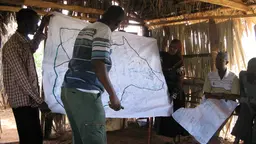
How can we incorporate local knowledge into climate planning and policy? …Maps!

Insight, 17 January 2020

Map before
Results from the Karonga Mapathon

Insight, 31 March 2016

Top: Sohel Ahmed and colleague prepare to release the balloon; bottom: Some of the photographs taken from the air (Photos: Sohel Ahmed)
Up in the air: Citizen scientists map food dangers in Nairobi

Insight, 31 March 2014

No description available.
Community maps reveal rich resources of land policymakers think is empty

Insight, 25 April 2013

Related tags
Informal settlements (slums)
India
Urban Matters blog
Kenya
Technology and innovation

Footer

  • News and insight
    • Insights
    • News
    • Events
    • In conversation
    • Podcasts
  • Our approach
    • Manifesto
    • Partnerships
    • Process
    • Impact
    • Hidden handbrakes
  • Publications
    • About publications
    • Accessibility
    • Privacy policy
    • Media centre
    • IIED Europe
  • About
    • Contact us
    • Raise a concern
    • Accountability
    • People
    • Jobs and internships
Subscribe to newsletters back to top

© 2026 International Institute for Environment and Development (IIED)

Accessibility Privacy policy Terms and conditions Cookie preferences